 |
| Jimmy Cornell presents Cornell’s Ocean Atlas Photo: Hasse Ferrold |
It’s all too easy to follow the crowd on the well-worn rut around the world without doing your own diligent voyage planning and still expect to experience reasonable conditions doing so.
But the moment you think about bearing off left or right — treading the path less taken, as it were — when everyone else is going straight, having the knowledge to keep yourself in safe and comfortable sailing conditions becomes crucial.
An exceptional new tool has appeared on the scene to help every cruiser work out for him/herself the possibilities open to them to be adventurous while staying safe, and that new tool comes from one of the most respected names in cruising — Cornell.
World-renowned sailor and cruising author Jimmy Cornell and his son Ivan Cornell have teamed up to pair modern weather technology with the most classic of voyage planning tools– pilot charts. The result is Cornell’s Ocean Atlas: Pilot Charts for All Oceans of the World.
What is the difference between Cornell’s Ocean Atlas and traditional pilot charts?
 |
| U.S.N. Matthew Fontaine Maury 1855 (from en.wikipedia.org) |
Pilot charts, first developed in the late 19th century by US Navy Lieutenant Matthew Fontaine Maury, consolidated weather, wind and current data gleaned from shipmasters’ logbooks. The purpose was to help captains plot routes across the sea that maximized favorable weather and sea conditions and avoided unfavorable ones. Prior to Maury’s efforts there was no reliable resource for this information.
In the decades since Maury, pilot charts have been relied upon by all serious seafarers. Though updated periodically since then, traditional pilot charts continued to rely on data provided by shipmasters. and cruising sailors often found themselves in conditions not in alignment with what the pilot charts predicted.
In part, those differences stemmed from recent climate changes and in part from the weaknesses of uneven data collection and uneven standards of reporting. Consider that the majority of those intrepid shipmasters whose reports contributed to the making of traditional pilot charts were sailing commercial routes with the result that the bulk of reports came from major shipping lanes, while less travelled regions like the tropics or high latitudes were under-reported.
Most cruising sailors quickly discover the inaccuracies of traditional navigation charts for the out-of-the-way places we like to explore, since the original explorers’ chartings have been little refined because the areas experience relatively light traffic. The same is true for pilot chart data. Think of any region you have sailed regularly and consider whether you would want to plan a voyage there based on the reports of just a few vessels.
Additionally, the large ships of a century ago needed more wind to sail, so that anything less than 12-15 knots might be considered a calm! At the same time, think how many open-sea tropical storm tracks which never made landfall or crossed major shipping lanes went unreported in eras before our modern weather-tracking eyes in the sky.
To present a much more accurate picture the Cornells have used computers and twenty years of the latest data collected from weather satellites constantly scanning all parts the globe. As they anticipated, this has revealed many areas of inaccurate information. In the Introduction, the authors highlight a very specific example of the difference this can make to sailors setting out on a Pacific crossing.
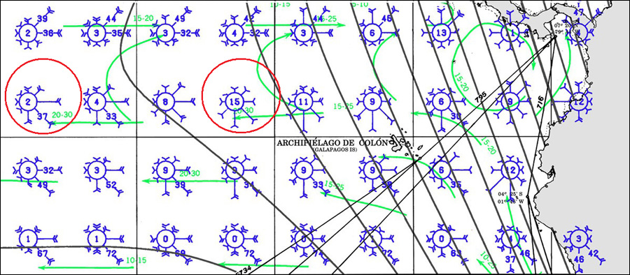 |
| Pacific Ocean / March, Old |
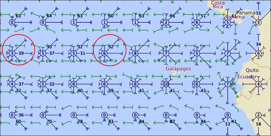 |
| Pacific Ocean / March, New (Cornell’s Ocean Atlas) |
For cruisers, there were also some practical issues with old-style pilot charts. A large ship with a big chart table in the bridge has plenty of room to lay out the charts needed to cover a entire voyage, but a private sailboat has more cramped nav stations. In a typical cruising boat like ours was, it was hard to lay out and compare charts for our course across the Pacific from Puerto Vallarta, Mexico to the Marquesas, because we needed pilot charts for both the northern and southern hemispheres. For a trip around the world one might need as many as eight sets of pilot charts!
So another improvement on traditional charts that the Cornells have made in their Atlas is that they have sized the set to fit comfortably on a sailboat’s nav desk, and framed the pages to present the data cruising sailors would need on typical passages. So, for example, a cruiser planning a Pacific voyage has 47 pages of pilot chart info for that crossing, with the whole Pacific shown on the right-hand page and on the left more detailed data for the sections cruisers typically are at any given month of the year. And, all the oceans of the world are included in just one book!
Furthermore, Cornell’s Ocean Atlas is annotated with commentary about climate patterns and conditions to plan for based not only on the Cornells’ extensive world sailing experience, but input from some of the most respected and familiar ocean weather experts from Europe, the USA, and New Zealand.
 Even with all these improvements, pilots charts can still appear to be for the new cruiser a mind-boggling tool to master. Flip open to any page and there are all these small boxes with green arrows, red lines and mysterious wind-rose symbols that look like a child’s game of jacks!
However, the system is clearly explained in Cornell’s introduction, and with just a little application, it will soon appear intuitive.
Recently I sat in on Jimmy Cornell’s first SSCA (Seven Seas Cruising Association) webinar on using the World Atlas charts for voyage planning from which I picked up his simple yet ingenious technique for applying the pilot chart information to any passage. Simply lay a piece of string on the rhumb line from point A to Point B, then use you finger to curve the string into a course line that maximizes your passage-making conditions, then pencil in your final course and, of course, make note of the waypoints.
Cornell’s Ocean Atlas is a serious tool for any cruiser planning any ocean passage.
As the Cornells conclude in their Introduction, “Our main objective (in Cornell’s Ocean Atlas) has been to create the kind of publication we would have greatly appreciated if it had been available when we sailed on any of the five circumnavigations of the globe which we share between us.”
 |
| Ivan and Jimmy Cornell, Cape Horn |
More information (external links)
- Find out more about Cornell’s Ocean Atlas
- Read the complete introduction to Cornell’s Ocean Atlas
- About Jimmy Cornell
- About Ivan Cornell
- About US Navy Lieutenant Maury (Wikipedia)
Read also on this website
- Book Review – A Passion for the Sea by Jimmy Cornell
- World Cruising Destinations, Jimmy Cornell’s new book!
- All book reviews
If you have a book that like us
you would like to review,
let us know!Email kathy@forcruisers.com or leave a comment below.